

| Dept. Earth & Ocean Sci. |
|
Marine Science Program |
|
News & Events |
|
Local Links |
|
Contact |
|
|||||||||||||||||
|
|||||||||||||||||
|
Active Research Projects at the CPSD Lab
|
|
Benthic Observatory and Technology Testbed on the Mid Shelf - Understanding Processes
The CPSD Lab is responsible for carrying out measurements in the benthic boundary layer (BBL) that aim at characterizing the seabed response to physical forces acting across a spectrum of time scales. The frequency, intensity, and timing of energetic events are detected within the water column, and their manifestation within the BBL is measured. The BBL characterization involves installation of instrumented tripods (see picture on right) that collect data utilized to measure thresholds of bed motion and characterize near-bed suspended loads. These data are also used to estimate pressure fields and advective fluxes at the interface. The tripod is instrumented with ADVs, AquaDop Current Profiler, Pressure sensors, an upward and a downward looking, 4 frequency Acoustic Backscatter Sensor, and two Wetlabs Chlorophyll-a sensors.
Above: Examples of two typical seabed conditions observed during the stduy (i) Rippled bed in response to surface wave forcing; (ii) Falt bed with signs of biological activity. Click on the thumbnails for better resolution images.
Click Here to see most recent images. (link will take you to Skio Homepage, press back to come to this page again)
Numerical Study of the Physical Conditions that Lead to Hypoxia Events in Long Bay, SC
The overall objective of this project is to identify the physical scenarios under which low oxygen events in Long Bay may occur, and to provide insights into threshold conditions to predict the occurrence of these events that can be used by coastal managers. In order to do this, we have utilized a numerical model (ROMS) to carry out numerical experiments that are driven by realistic conditions as measured in the field. The main objectives of the study are:
(1) Influence of the coastline configuration and bathymetric features on the wind-driven circulation in a strong vertically stratified inner-shelf
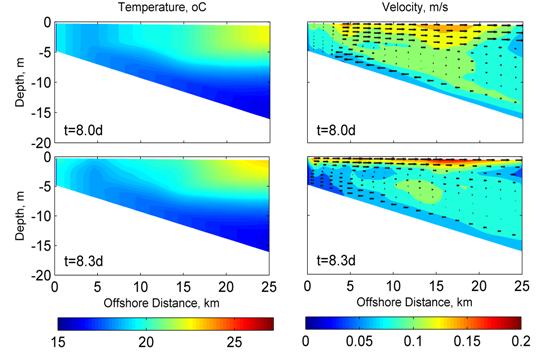
Numerical simulations were carried out using a 3-D numerical model (ROMS) for an idealized bathymetry and coastline configuration with general characteristics resembling those of Long Bay, SC. These results were also compared to results from a domain with a straight coastline and similar shelf bathymetry. The numerical results show that inner-shelf circulation is highly rectified by the curved coastline configuration. While for a straight coastline all hydrographic parameters and flows are uniform in the alongshore direction, the curved coastline and presence of capes, such those of Cape Fear, NC and Cape Romain, SC, create significant alongshore variations. These variations generate alonsghore circulation gradients that lead to areas of divergence and/or convergence and as such might affect the spatial distribution of dissolved and suspended material. Furthermore, these gradient lead to the generation of preferential upwelling areas that are associated with the capes.
(2) Physical scenarios under which the Gulf Stream cold-water intrusions can reach the inner-shelf and the relative importance of each forcing mechanism on that event
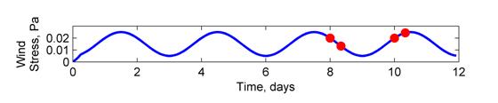
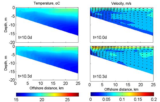
Although hypoxia exhibits itself as a biological effect, its formation and maintenance depends primarily on the existence of the appropriate physical conditions that can lead to stratification of the water column, a physical process that limits the oxygen exchange with the atmosphere. It has been observed that low-oxygen events in Long Bay occur during upwelling favorable wind conditions. Numerical simulations showed that under such conditions and in the absence of any strong solar radiation and/or stratification by buoyant fluxes, the wind stress will break down any vertical stratification and as such no hypoxic event could occur.
The numerical simulations showed that only under periodic (oscillatory) wind forcing and strong summer solar radiation, thermal stratification can be maintained and offshore colder and potentially nutrient rich water can come to the nearshore. According to the numerical model, under these conditions Gulf Stream bottom water found in the middle shelf can be transported onshore to the nearshore and promote low oxygen conditions. This intrusion will occur only during upwelling oscillatory wind events and the action of strong solar radiation (i.e. summer condition). Observations of hydrographic and meteorological data confirm the numerical results. We are currently working in implementing an oxygen consumption module on the model to investigate the potential of generating low oxygen conditions directly
Toward an Enhanced, State-of-the-Art Nearshore Forecasting System
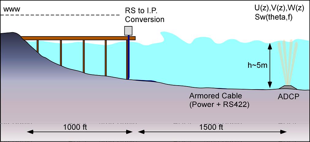
This work is carried out as part of a larger project referred to as: Integration of Coastal Observations and Assets in the Carolinas in Support of RCOOS development in SECOORA. This is a Regional Project with partners from UNC-Wilmington and the Army corps of Engineers Field Research Facility (ACE-FRF Duck, N.C.). Along the Atlantic, most of the waves are locally generated by the prevailing wind conditions. As such, the waves measured by offshore buoys are modified as they travel toward the beach through wave refraction, diffraction, energy dissipation and also from local winds. As part of the South East Atlantic Coastal Ocean Observing System (SEACOOS), the CPSD Lab installed and operates two nearshore (2000 ft off the shoreline) real-time directional wave and current measurement stations along the coast of South Carolina (Folly Beach near Charleston, and Springmaid Pier, near Myrtle Beach).
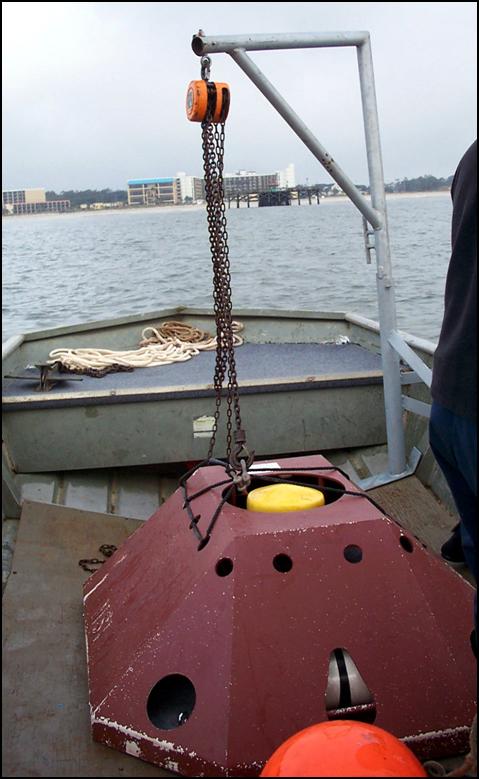
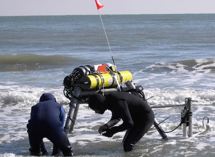
Click on the thumbnails above to see (i) schematic showing the arrangement of the Pier-based South Carolina Nearshore Monitoring Systems; (ii) the underwater part of the installation, housing the RDI ADCP; (iii) and (iv) photos of instrument deployment to measure surf hydrodynamic conditions to be used for the development of the models. Despite these developments in the monitoring front, there is still the need for development of added-value products that will appeal to and serve scientists and managers from other disciplines including ecology, biology, coastal engineering, coastal management, local municipalities, and the general public. Furthermore, these monitoring stations provide measurements at single locations and unfortunately do not account for local varying topography and wind forcing which might modify wave conditions in adjacent locations.
The current work aims at the development of added-value, physics-based products of regional importance and of sufficiently high resolution to reflect km scale differences in the coastline. This product includes the development, calibration and utilization of numerical models that will be used initially to nowcast and following integration with an operational forecasting wave model. capable of predicting longshore and rip-current conditions in the surf–zone, an area with high recreational and local economic value.
Sorted Bedforms; Modeling and Observations to Test a New Hypothesis for Rippled Scour Depressions
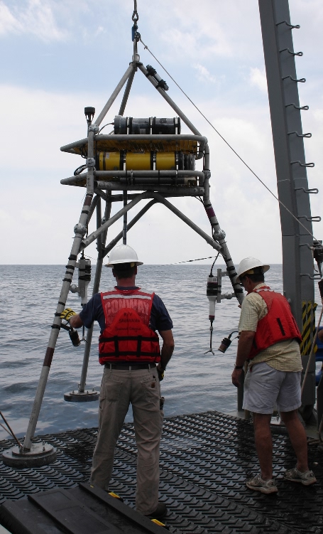
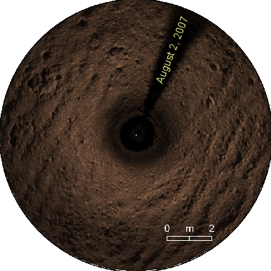
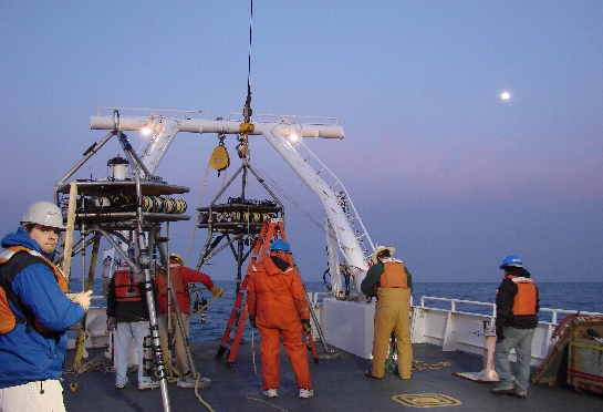
On-going analysis of experimental data (Gutierrez et al, 2006) and theoretical work by our collaborator Dr. Brad Murray (Duke University) indicates that the large wave-generated ripples that form in the course material cause wave motions to produce near-bed turbulence that is greatly enhanced relative to that in other areas. The enhanced turbulence apparently prevents fine material from resettling on the collections of course sediment. Instead, fine sediment will be carried by mean currents past the course accumulations, and deposited further down along the trajectory of the flow. This process creates separate domains of coarse and fine accumulations in the shelf region. Above left: Jonathan Borden of the US Geological Survey is operating a ROV for inspecting sea bed conditions prior the deployment of a an instrumented tripod. Right: Image of sea bed status obtained with the ROV camera.
The CPSD Lab is leading the field measurements of turbulence through installment of observation tripods in the two domains. The platforms collect information on near bed stress, and suspended sediment concentrations using optical backscatter sensors, acoustic Doppler velocimeters (ADV) and current profilers. These measurements are currently analyzed to rigorously characterize the hypothesized interaction between course concentrations and sediment entrainment and deposition. This information, fundamentally valuable on its own, will also be used to direct and constrain the modeling effort. The tripods were deployed in the period January 29 to May 7, 2007. In addition, synoptic physical oceanographic measurements with ship mounted ADCP and periodically deployed CTD were collected during the cruise to examine the large scale forcing of flows in the area. This research could potentially explain the origin of features that have recently been found to be ubiquitous on parts of the inner shelf of the East Coast, and are widespread on other shelves as well.
Example of Ripple profile obtained by the profiler on one of the tripods (above left) and the time-series for the full deployment period of 3 months (above right).
Physical Controls on Benthic Fluxes of Microalgae and Particulate Organic Matter in Estuarine Environments
Estuaries make up approximately 80% of the Atlantic coastline in the United States. These systems are ecotones forming the point at which freshwater and coastal marine communities interact directly. Chemical and biological interactions in the benthic environment and water column create intricately complex and highly sensitive ecosystems such as oyster reefs and microphytobenthic communities in the sediment, and seasonally shifting phytoplankton communities in the overlying waters. The sediment-water interface is a dynamic boundary where material fluxes are an important determinant of the biogeochemistry and ecology of aquatic ecosystems. Perturbations through human interactions can and often do lead to alterations in aquatic systems. Eutrophication (total increase in organic matter delivery and production in the system), and alterations in light and hydrodynamic structure (associated with physical resuspension activities such as boat wakes, waterway construction, dredging and trawling) are examples of anthropogenic perturbations that may ultimately lead to shifts in dominant communities. Management of coastal systems directed at long term effects of eutrophication relies on model analysis of benthic data because sediments have the capacity to carry a “memory” of past nutrient inputs and to convey that memory back to the water column through diffusion and resuspension. Integrated modeling of such environments should incorporate hydrodynamic and geochemical process models that link hydrodynamics, particle dynamics and geochemistry to study the effect of re-suspending particles from the sedimentary environment. These models must have the capacity to accurately simulate bottom shear stress representing the potential for resuspension across the sediment water interface as well as the relationship between shear stress and biomass indicators such as chlorophyll introduction.
The overall long-term objective of this study is to create a biogeochemical module that can be integrated with hydrodynamic models to simulate fluxes of benthic microalgae (BMA), non-living particulate organic matter (POM), and the particle size distribution of suspended sediments (SS) under turbulence conditions of tidal and wind-induced flows. The short-term objectives to be achieved within the 2-year length of the proposed project are:
(1) Determine experimentally the relationship between physical hydrodynamic forcing and re-introduction of BMA, POM, and SS into the water column, in a tidally dominated environment for different seasons. (2) Differentiate the particle dynamics of benthic sediment and BMA. (3) Parameterize benthic fluxes of BMA fluxes into a geochemical module that can be integrated in physical numerical models.
In order to achieve our objectives we will set-up experiments during winter and summer for neap and spring tides on a location at North Inlet, SC. We will collect water samples and sediment cores and carry out analysis. Autonomous data collected from deployed instruments will be analyzed for quality assurance and laboratory determination of water column parameters will be completed. Initial assessment of interrelation between turbulence derived resuspension and BMA and POM introduction will be completed. We will complete parameterization of resuspension derived module from analysis of field data and continuous turbulence and boundary layer observations. Test module with an established hydrodynamic model in order to assess capacity of BMA and POM of resuspension to the experimental site.
The USC WERA-HF Radar System
These HF-radars are long-range WERA installations manufactured by Helzel MessTechnik of Germany. They operate at a frequency of 8.3 MHz, and measure near surface currents (upper ~one-meter depth) along radials towards or away from each installation. Each radial extends over 120km (during daytime) and the radials span a region +/-60 degrees from the perpendicular of the linear antenna array. In the region where the USC and SKIO installations overlap at a sufficient angle, 2-D vector velocities can be constructed from the radial velocities.
The USC installation if located at Pritchard's Island, a pristine barrier island on the South Carolina coast. The electronics are housed on the Marine Laboratory operated by the University of South Carolina, Beaufort, while the SKIO installation is on St. Catherine's Island GA.
|

 This
is a multidisciplinary, collaborative research project with
scientists from the Skidaway Institute of Oceanography (SKIO, GA)
that examines exchange of particulates and solutes between the sea
bed pore space and the overlying water. The advective fluid exchange
driven by near-bed pressure gradients is generated by the interaction
of near-bed fluid flows and benthic microtopography (i.e., wave
induced ripples and biologically generated mounts). Such continuous
circulation of overlying water through the pore space greatly
increases the coupling of the pelagic and benthic ecosystem. The
study site is located off the coast of Georgia, where the continental
shelf is broad, shallow and underlain by permeable sands. Four
instrumented platforms make up the SABSOON Network (U.S. Navy) and
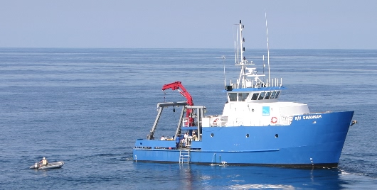
these are the backbone of our benthic observatory. The R/V Savannah,
a UNOLS vessel managed and operated by SKIO is used for our sea
operations.
This
is a multidisciplinary, collaborative research project with
scientists from the Skidaway Institute of Oceanography (SKIO, GA)
that examines exchange of particulates and solutes between the sea
bed pore space and the overlying water. The advective fluid exchange
driven by near-bed pressure gradients is generated by the interaction
of near-bed fluid flows and benthic microtopography (i.e., wave
induced ripples and biologically generated mounts). Such continuous
circulation of overlying water through the pore space greatly
increases the coupling of the pelagic and benthic ecosystem. The
study site is located off the coast of Georgia, where the continental
shelf is broad, shallow and underlain by permeable sands. Four
instrumented platforms make up the SABSOON Network (U.S. Navy) and
these are the backbone of our benthic observatory. The R/V Savannah,
a UNOLS vessel managed and operated by SKIO is used for our sea
operations.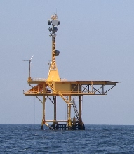
 Present
SABSOON instrumentation installed on or near the R2 US Navy Tower
(see picture on left) includes meteorological packages, ADCPs,
surface and bottom CTDs, fluorometers and PAR sensors. In addition
the team has installed additional sensors designed to measure fluid
forces and physical and geochemical responses near, at, and within
the seabed.
Present
SABSOON instrumentation installed on or near the R2 US Navy Tower
(see picture on left) includes meteorological packages, ADCPs,
surface and bottom CTDs, fluorometers and PAR sensors. In addition
the team has installed additional sensors designed to measure fluid
forces and physical and geochemical responses near, at, and within
the seabed. 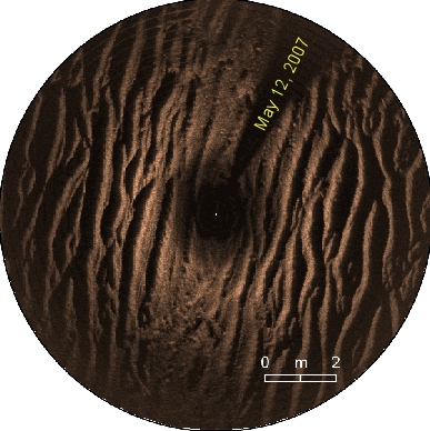


 This project aims at studying specific sites of the shoreface and inner
shelf around Wrightsville Beach, North Carolina. The regions show
numerous collections or pockets of relatively course sediment, which
extend kilometers in the cross-shore direction and are on the order of
100 m wide. These features in several coastal regions have been called
rippled scour depressions, but the recent observations strongly suggest
that they may be best described as “sorted bedforms.” They exhibit
asymmetric but subtle bathymetric expressions: lows relative to their
surroundings on the updrift side of the dominant mean current, and highs
on the downdrift side, with relief of approximately one meter. Sidescan
sonar observations suggest that some of the features off of Wrightsville
Beach migrated as much as half their widths due to strong wave forcing
associated with a recent storm.
This project aims at studying specific sites of the shoreface and inner
shelf around Wrightsville Beach, North Carolina. The regions show
numerous collections or pockets of relatively course sediment, which
extend kilometers in the cross-shore direction and are on the order of
100 m wide. These features in several coastal regions have been called
rippled scour depressions, but the recent observations strongly suggest
that they may be best described as “sorted bedforms.” They exhibit
asymmetric but subtle bathymetric expressions: lows relative to their
surroundings on the updrift side of the dominant mean current, and highs
on the downdrift side, with relief of approximately one meter. Sidescan
sonar observations suggest that some of the features off of Wrightsville
Beach migrated as much as half their widths due to strong wave forcing
associated with a recent storm.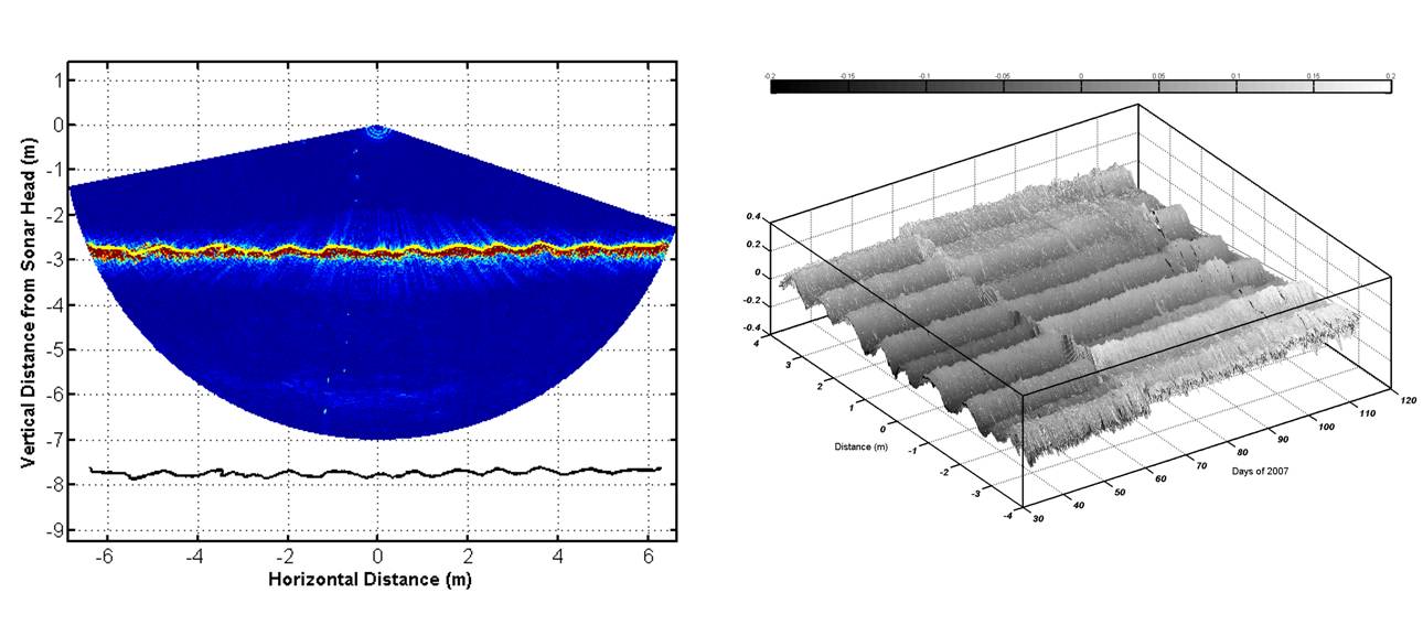
 The University of South Carolina (Department of Geological Sciences /
Marine Science Program) and the Skidaway Institute of Oceanography (SKIO,
GA) have installed two shore-based HF-radars along the South Carolina -
Georgia coastline to measure surface currents across the continental
shelf. The USC radar was installed with SEACOOS funding (through ONR)
and the systems have been operational since April 2006.
The University of South Carolina (Department of Geological Sciences /
Marine Science Program) and the Skidaway Institute of Oceanography (SKIO,
GA) have installed two shore-based HF-radars along the South Carolina -
Georgia coastline to measure surface currents across the continental
shelf. The USC radar was installed with SEACOOS funding (through ONR)
and the systems have been operational since April 2006.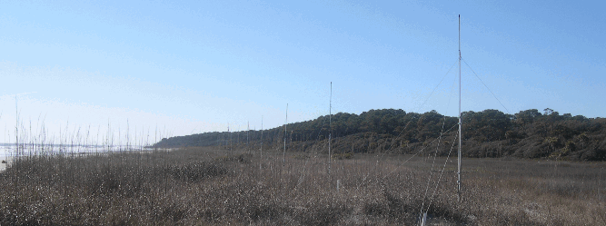

| USC LINKS: | DIRECTORY | MAP | EVENTS | VIP |
| Columbia, SC 29208 • Tel: (803) 777-2549 Fax: (803) 777 6610 • gvoulgaris<at>geol.sc.edu | © University of South Carolina Board of Trustees |